Loading...

Address: Brgy. Tandang Kutyo, Tanay, Rizal
Sub-Category: Other
Ownership: Private
Status: Occupied
Conditions: Good
Area: 700 hectares
Estimated Age: 1966/ 55 years
Owner Jurisdiction:
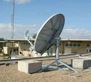
Description: A satellite is basically a self-contained communications system with the ability to receive signals from Earth and to retransmit those signals back with the use of a transponder—an integrated receiver and transmitter of radio signals. The Philippine Communication Satellite is erected at the mountains of Tanay at Pantay Road and within the boundary of towns of Baras and Teresa, and City of Antipolo. It provides the scenery-view of Sierra Madre Mountains. The cool breeze upholds you because of the high altitude. At the same time, there are plenty of trees and plants around the satellite area, and it provides a green environment at the top view. There are lots of satellites within the area and all of these are functional. Each satellite is made of strong metal with 30-40 feet in height and 25-30 width.
History Structure: The province of Rizal is the pioneer and foremost in communication technology in the Philippines where the first satellite, the “PHILCOMSAT”, was established in 1970s. This communication facility has broken down the barriers and open-up the Philippines in the advance communication system across the lands and oceans from fax services, broadcasting, telephone, and other satellite communication services. The Philippine Communication Satellite (PHILCOMSAT) was located at the boundary between Pantay Road, Tanay, Rizal and Palo Alto, Baras, Rizal. It is built under the leadership of President Ferdinand E. Marcos with the cooperation of Philippine Overseas Telecommunications Corporation by year 1966. It was considered by the government as the country’s representative on Intergovernmental Consortium Satellite Service Provider, a firm established by businessman Potenciano Ilusorio and then Defense secretary Juan Ponce Enrile
Stories: There is a territorial dispute between the Municipality of Tanay and Municipality of Baras in the Province of Rizal. It is clear that the PHILCOMSAT was established under the jurisdiction of Tanay by 1966. As time went by, the Municipality of Baras claimed their rights to the said area. By the virtue of Presidential Decree No. 1845 series of 1982, it is mandated that the only earth station in the Philippines for world satellite telecommunications is located in a remote and sparsely populated place in Sitio San Miguel, Barrio Pinugay, Municipality of Baras, Province of Rizal. The entire area surrounding the satellite earth station in the said place within a radius of three kilometers from said earth station is hereby declared a security zone. The entire area surrounding the satellite earth station in Sitio San Miguel, Barrio Pinugay, Municipality of Baras, Province of Rizal, Island of Luzon, within a radius of three kilometers, more or less, from the main satellite earth station, the metes and bounds of such area to be determined by the Secretary of the National Defense, is hereby declared a security zone. For this purpose, and in the interest of national security, ingress to and egress from the security zone as well as occupancy of portions thereof shall be controlled and regulated, without prejudice to the payments of just compensation to persons whose rights of ownership may be injuriously affected thereby. Meanwhile, the Sangguniang Bayan of Tanay, Rizal, in its Resolution No. 65-94 that was endorsed to Department of Agrarian Reform (DAR), moved for the coverage of the 700- hectare PHILCOMSAT property within the security zone under Comprehensive Agrarian Reform Project (CARP). The Provincial Agrarian Reform Officer of Teresa, Rizal further opined that subjecting the surrounding agricultural area within the security zone under CARP will not be detrimental to the operations of PHILCOMSAT. Until this time, the Municipality of Tanay filed a petition for reconsideration to talk about the territorial dispute against the Municipality of Baras. It is clear that the PHILCOMSAT was originally declared under the jurisdiction of the Municipality of Tanay before. As a proof, the icon of a satellite is shown on the Municipal’s official seal and logo.